THE URBAN SURVEY
|
|||||
| Kerkenes Home | Back to Contents Page | ||||
| Türkçe Çeviri | |||||
|
|||||
|
THE URBAN SURVEY |
|||||
|
|
 |
|
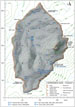
| Figure 18 | Figure
19 |
Figure
20 |
|
|
 |
 |
| Figure 21 | Figure
22 |
Figure
23 |
|
|
 |
|
Figure
24 |
||
| THE URBAN SURVEY | ||
Geophysical
Survey with a Resistivity Meter |
||
| In May, 15 days of remote sensing survey with a Geoscan RM15 resistivity meter were accomplished in the area of the palatial complex (Fig. 18). A total of 42,000 square meters of area (4.2 hectares) were surveyed, revealing the entire extent of the Palatial Complex, as well as significant portions of adjacent urban blocks | ||
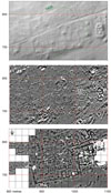
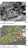
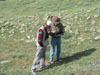
| At the Palatial Complex, resistivity survey readings were taken, as in previous years, at a sample density of two readings per meter. Numerous stones on the surface makes insertion of probes difficult (Fig. 19). While using extra-long probes so that stones could be straddled produced excellent results, the area that could be covered in one day was considerably reduced. The results of the 2006 and 2007 resistivity survey (Fig. 21c) at the Palatial Complex and surrounding area were examined together with existing sets of data from the GPS topographic (Figs 20 and 21a), aerial photography and gradiometer surveys (Fig. 21b). Images displaying raw data (Fig. 22a) and processed data were compared while observable features on the surface of the ground were documented. Finally, a preliminary plan of the Palatial Complex and neighbouring structures was drawn (Fig. 22b). | ||
| New Understanding of the Palatial Complex | ||
|
The new images (Figs
21 and 22)
permit new and more refined interpretations which, at some future date,
it will be important to verify by excavation. Firstly, it can be seen that the eastern end of the complex, dominated by the massive Structure A and its supporting stone glacis, appears to belong to an initial phase very possibly dating back to the foundation of the city. Only the eastern end of this defensive structure was to survive later modifications. To the west a large trapezoidal urban block some 140m in length, and thus the largest such block identified in the city, was laid out. The most significant structures within this block are a pair of large two-roomed buildings each comprising a rectangular hall and ante-room, located at the centre of the southern side. Dominating the other closely packed buildings within this block are rows of cells, presumably storage units. Perhaps a generation later the space between these two elements, the fortified strong point and the large residential block, was filled with public structures, notably the Audience Hall and the Ashlar Building, both of which have been investigated by excavation. The new resistivity images reveal a third major two-roomed building, perhaps with a hearth in the centre of the hall, across a paved court east of the Ashlar Building. In a final phase, not many years before the destruction and abandonment of the city, a new Monumental Entrance was inserted. This scenario, of four major phases of planned construction, cannot yet be proven. Doubtless there were many phases in the sequence of building and there could hardly have been a day of good weather without the clamour of workmen, the creaking of carts, and the squeals of animals hauling wood, mud, stone and thatch. These developments suggest ever growing confidence and prosperity with an original emphasis on defence replaced, after two or three generations, by palatial buildings approached through a splendid gated court overlooked by large semi-iconic stone idols, statuary and a sculpted monument bearing an inscription in the Old Phrygian language. One can well imagine the Kings of Pteria holding court in the Audience Hall. To the north of this great compound we see smaller urban blocks divided by a grid-like pattern of streets indicative of central planning. Although details are not always easy to see the overall character of these blocks is very clear. They are much smaller versions of the original block of the palatial compound. Prominent rows of small cells suggest emphasis on storage while two-room buildings, presumably residences, are suitably smaller than the large pair in the palatial block. Exceptional, and known to us since our first season, is the very large building towards upper right in the image. Clues as to the function of this special building are elusive, no internal fittings or features being visible. It is hard to avoid the suggestion that it is a temple. |
||
| Groundtruthing and Recording | ||
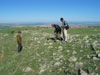
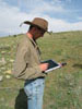
| Progress was made in recording and photography of the more recent tumuli and animal pens constructed in the Palatial Complex area. Groundtruthing was carried out with the help of the tablet computer (Fig. 23) to identify on the ground features revealed by the remote sensing surveys. | ||
| As last year, this data was used with a Global Positioning System (GPS) and the tablet computer to check more of the ancient city plan against features visible on the ground surface. The tablet computer was also used to navigate along the ancient streets of the city (Figs 24a and b) and to select locations for the transportation test trenches excavated in 2007. | ||
| Data Processing and GIS | ||
| Significant
work was also accomplished on analyzing and transforming the resistivity
data from previous seasons in the lower area of the city. Processing of
the new resistivity data from the Palatial Complex area is ongoing while
new ways of combining and fusing results form different sets of data are
being investigated. GIS studies continue with the different sets of data. A paper by Geoffrey Summers, Françoise Summers and Pinar Kaymakçi was presented at the 2007 ESRI Users Conference which was held at METU Conference Center in October 2007. |
||
| Kerkenes Home | Back to Contents Page | ||||
| Türkçe Çeviri | |||||