EXCAVATION
OF TEST TRENCHES ACROSS STREETS WITHIN THE CITY
|
|||||
| Kerkenes Home | Back to Contents Page | ||||
| Türkçe Çeviri | |||||
|
|||||
|
EXCAVATION
OF TEST TRENCHES ACROSS STREETS WITHIN THE CITY |
|||||
|
|
 |
 |
| Figure 25 | Figure
26 |
Figure
27 |
|
|
 |
 |
| Figure 28 | Figure
29 |
Figure
30 |
|
|
 |
 |
| Figure 31 | Figure
32 |
Figure
33 |
|
|
 |
 |
| Figure 34 | Figure
35 |
Figure
36 |
| EXCAVATION OF TEST TRENCHES ACROSS STREETS WITHIN THE CITY | ||
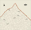
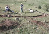
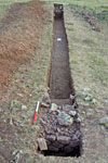
During
June and the first week of July, seven test trenches were excavated in
the northern portion of the city (Fig.
25). All of the trenches were 1m wide and varied in length from 9.5m
to 23.5m. These test trenches continued the program, started in 2004,
of excavating across the ancient city streets to test computer simulations. These simulations, similar to those used by city planners in modern cities to analyze traffic, reveal how people once used this ancient city. The simulations tell us which are the main streets and which are very minor streets within the city. They can also provide information about urban blocks, revealing which ones might have been public and which others might have had a more private function through analysis of traffic volumes, origin and destinations. Soil samples were taken from each street and, as was done in 2004, shipped for analysis at the McBurney Geoarchaeology Laboratory at the University of Cambridge in England. There the samples will be analyzed in order to test the results of the computer simulations. |
||
Test Trenches |
||
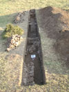
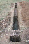
| The
Test Trenches (TT), named in sequence from TT26 to TT32, were positioned
using the remote sensing plan of the city so that the ends of each trench
were just inside the dry laid granite wall footings of the adjacent urban
blocks. Thus each test trench ran over the urban block walls on either side
of the street and across the entire width of the street area (see Fig.
26 for TT26). Each trench was excavated down to the bedrock with the exception of TT28 whose southern wall had been built on rubble filling of a fissure in the bedrock. The specifics of each test trench are described below. |
||
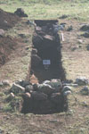
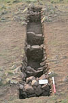
| TT26 was 10.2 by 1m and reached a maximum depth of 1.15m (Fig. 27). Two dry laid granite urban block wall footings were found. The first in the northeastern part of the trench was the outer wall of the urban block to the northeast of the street. It was 1.2m wide and had a preserved height of 80cm. The second was in the southwestern part of the trench and was the outer wall of the urban block to the southwest of the street. It was 1.05m wide and had a preserved height of 75cm. The total width of the street area between these two partially collapsed walls was 6m. | ||
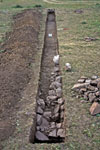
| TT27 was 18.8 by 1m reaching a maximum depth of 1.55m (Fig. 28). Only the bedrock foundation of the northern outer urban block wall has survived. The southern urban block wall was 80cm wide and still stood 35cm high. Both walls had collapsed into the 9.1m area between the two walls through which the street would have run. In addition, the base of two walls were exposed within the southern urban block. The first, with a preserved height of 43cm, ran perpendicular to the outer urban block wall and had been broken in two. The second, preserved to a height of 25cm, was set back from the first and was parallel to it. | ||
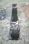
| TT28 was 9.4 by 1m and reached a maximum depth of 1.6m (Fig. 29). The outer urban block wall to the northeast of the street area was 75cm wide and 45cm high. The outer urban block wall to the southwest of the street area was 1.5m wide and 80cm high. Both walls had partially collapsed into the 5.05m wide street area between the two urban blocks. | ||
| TT29 was 23 by 1m and reached a maximum depth of 2.18m (Fig. 30). In addition to a street area running between the two urban blocks, there was also a deep cut into the bedrock for a pool of water and a smaller water channel parallel to it. The outer wall of the urban block to the east, which was also the outer wall of a small two-roomed building just inside the urban block, was 1.2m in width and preserved to 1.2m in height. The outer wall of the urban block to the west was 65cm wide and 90cm high and was laid in a foundation trench cut into the bedrock. Both walls had partially collapsed into the street area and water features which together were 19m wide. | ||
| TT30 was - 23.55 by 1m and reached a maximum depth of 70cm before hitting bedrock (Fig. 31). The wall of the urban block to the north was 85cm wide and preserved to 40cm in height. The wall of the urban block to the south was 1.4m wide and also 40cm in height. A later wall, preserved 31cm, had been built abutting the urban block wall to the south, which narrowed the 20.2m street area between the urban blocks. | ||
| TT31 was 19.74 by 1m and reached a maximum depth of 98cm (Fig. 32). The wall of the urban block to the northeast of the street area was 1.16m wide and preserved to 65cm in height. The wall of the urban block to the southwest of the street area was 80cm wide and preserved to a height of 75cm. Both walls had partially collapsed into the 16.15m area through which the street had run between the urban blocks | ||
| TT32 was 11.4 by 1m and reached a maximum depth of 1.75m (Fig. 33). The wall of the urban block to the southeast was 80cm wide and preserved to a height of 60cm. An additional wall, 55cm wide and with a preserved height of 20cm, had been built within the area between the two urban blocks just in front of the southeastern urban block wall. No comparable urban block wall was found to the northwest of the street. Instead there was a series of threshold stones and upright stones that might represent steps up into this urban block. The northernmost wall within the trench appears to be a corner of a small structure within the urban block. It was made of much smaller stones, was 50cm in width, and was preserved to a height of 60cm. | ||
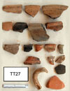
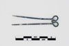
| None of the street areas exposed in these excavations were paved, all were dirt roads. From each test trench occupation material was recovered, both inside the small exposures of urban blocks and from the area of the street, and is being analyzed. These include animal bone, pottery (see Fig. 34 for a selection from TT27), seeds and some fragments of metal objects. One complete double looped copper alloy hairgrip was found just inside the southern urban block in TT27 (Fig. 35). The bone and seeds recovered are being sent to METU for analysis. Additional soil samples taken in each test trench will be analyzed at the University of Utah. | ||
|
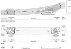
Once excavation and recording were completed the bottom of each test trench
was covered with geotextile, to preserve the surfaces and minimize plant
growth, urban block walls were rebuilt so that they stand two courses above
the surface of the ground, making them visible to visitors, and then the
entire test trench was backfilled. Such backfilling is necessary for the
safety of people and animals and also preserves the original walls and surfaces
that would not survive the harsh winters if left exposed. Plans and sections of the trenches (see Fig. 36 for TT26) are being prepared for final reports and publications. |
||
| Kerkenes Home | Back to Contents Page | ||||
| Türkçe Çeviri | |||||