THE URBAN SURVEY
Two weeks of fine May weather permitted substantial expansion
of the Resistivity Survey in the lower, central portion of the
city (Fig. 3).
The ground was moist and soft so that on most days nine grids,
each measuring 20 by 20m, could be surveyed. This broader survey
area now makes it possible to recognise significant differences
in spatial patterning across this central portion of the city.
As a result of warm and sunny conditions the higher ground soon
began to dry out and turn brown. By mid May only the marshy
area between the western and central zones, which appears to
be devoid of remains, remained wet. A month later the entire
area was dry and parched with cracks appearing in the ground.
It is striking how the environmental conditions alter from year
to year because of variation in the levels of snow and rainfall
throughout the winter and spring
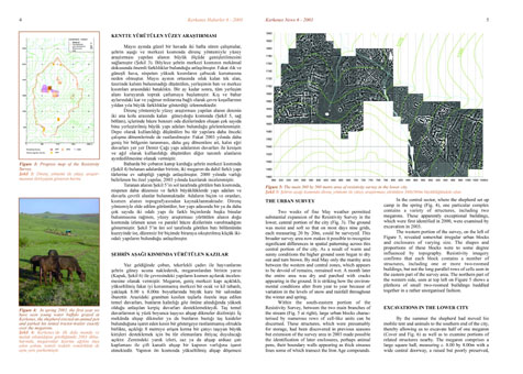
Within the south-eastern portion of the Resistivity Survey,
between the two main branches of the stream (Fig. 5
at right), large urban blocks characterise by numerous rows
of cell-like units can be discerned. These structures, which
were presumably for storage, had been discovered in previous
seasons but extension of the survey area in 2003 made possible
the identification of later enclosures, perhaps animal pens,
their boundary walls appearing as thick sinuous lines some of
which transect the Iron Age compounds.
In the central sector, where the shepherd set up camp
in the spring (Fig. 4),
one particular complex contains a variety of structures, including
two megarons. These apparently exceptional buildings, which
were first identified in 2000, were examined by excavation in
2003. The western portion of the survey, on the left of
Figure 5, revealed somewhat
irregular urban blocks and enclosures of varying size. The shapes
and proportions of these blocks were to some degree influenced
by topography. Resistivity imagery confirms that each block
contains a number of
structures, including one or more two-roomed buildings, but
not the long parallel rows of cells seen in the eastern part
of the survey area. The northern part of the western side, seen
at top left on Figure 5
shows a plethora of small two-roomed buildings huddled together
in a rather unorganised fashion.


